The Missouri Breaks: A Hunter's Introduction
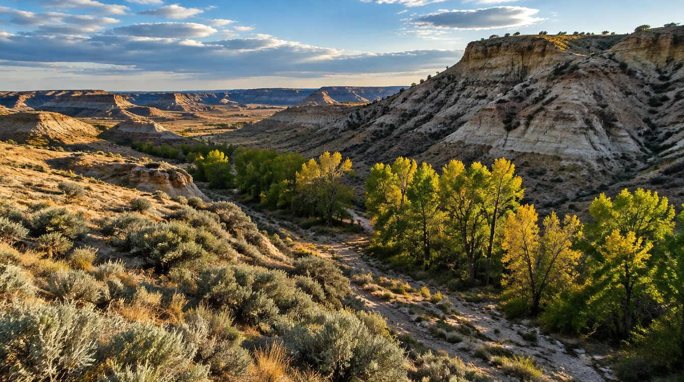
You drive north off the interstate and the country starts to come apart. The wheat ground rolls for a while, and then it breaks into coulees, gumbo slopes, and pale benches. Those benches step down toward a river you cannot see. The Missouri Breaks does not announce itself from the road; it arrives as a series of decisions about which ridge leads where, and most of them are wrong the first time.
Most of Montana lets you see an animal and lets it see you back, but here the land hides you both. The hunt stops being about distance and starts being about reading ground, and that shift is the whole draw. Not an easy tag, not a crowded unit, but big empty country that rewards the hunter willing to walk and think.
Hunters come here for one of two reasons, and it is worth knowing which one you are. Some want a bighorn sheep tag, which is a dream most will never draw. Others want to see the country, hunt what it holds, and learn a landscape that does not look like anywhere else in Montana. This page is for both, and it will tell you plainly which parts are real and which are folktale.
The quick facts
Every figure below carries its year, because FWP resets seasons and deadlines annually. Re-verify each one against the current regulations before you buy or apply for anything.
| What it is | A river-carved landscape, and a name FWP uses for a hunting district |
| The district | FWP names District 700 "Missouri Breaks–Prairie" in its regulations |
| FWP regions | The Breaks spans Regions 4 and 6; FWP's bighorn page leads with Region 6 |
| Marquee animal | Bighorn sheep, draw only |
| Other game | Mule deer, elk, and prairie upland birds |
| Main land manager | BLM, which holds about 8.3 million acres across Montana and the Dakotas |
| Sheep deadline | May 1, 2026; draw results mid-May |
| 2026 rifle season | Oct 24 – Nov 29, for deer and elk |
| The real problem | Public ground exists, but the access is a map problem first |
What the Missouri Breaks actually is
Start with the name, because it is doing two jobs at once.
The Missouri Breaks is a landscape, and it is the broken country the Missouri River cut on its way across northern Montana. A wide band of badlands, bluffs, and grass benches runs through it. The country looks less like a mountain state and more like a dry, rumpled sea. The Breaks is what happens when a river spends a long time arguing with the plains.
The Missouri Breaks is also a name FWP uses in the regulations. The 2026 Deer/Elk/Antelope Regulations name District 700 "Missouri Breaks–Prairie." That writes the landscape into the rulebook as a real unit, not just a place on a map. That naming is worth understanding next to the district-numbering rule, which we walk through in how to read a Montana hunting district.
The geography is bigger than one district or one region. The Breaks spans FWP Regions 4 and 6 — the North-central region out of Great Falls, and the Northeast region out of Glasgow. Start with the Region 4 overview for the country west of the breaks, and read the Region 6 overview for the Glasgow side. It is worth reading both, because which office you deal with changes how you plan a trip.
Do not let the names tangle you up on the way in. The country the Breaks describes runs across Regions 4 and 6. A district named for it — District 700, “Missouri Breaks–Prairie” — sits in the 700-series, which by the numbering rule is Region 7. The name travelled farther east than the land did, so read the district number and the region separately, every time.
That sprawl is the first thing to absorb: the Missouri Breaks is not a unit you draw. It is a country that happens to sit inside several units, and the rules change as you move across it.
The marquee animal: bighorn sheep
There is one animal that puts the Breaks on a hunter's map before anything else, and it is the bighorn sheep.
Montana holds Rocky Mountain bighorn herds in its western ranges, and it also holds a separate, hard-country population in the Breaks. FWP's bighorn sheep page names the Missouri Breaks as a sheep area and leads with Region 6 and hunting district 482. The state's sheep quota districts include HDs 500–502. Bighorn sheep in Montana are draw only, and the tags come in two flavors: limited and unlimited licenses, which are different applications with different rules.
Here is what the draw actually looks like: it is one of the hardest tags in the state, and not a permit you build toward casually.
Apply through the May 1, 2026 deadline, with results in mid-May. Those same dates govern moose, mountain goat, and bison, so if you chase any of the once-in-a-lifetime animals, one window covers them all. Your bonus points apply here as they do to other limited-entry permits, and they are squared before the draw, which is the mechanic that most improves a long-held application.
Now the dose of reality that belongs on this page. Montana's own lottery draws include permits whose odds run worse than 100 to 1, and sheep sits at the top of that list. The North Clark Fork bighorn draw pulled 1,234 applicants in 2020 and 463 in 2021, a swing that shows how much a single year can move an applicant pool.
If you are starting from zero, you are not applying for a sheep tag this year; you are applying so that, some years from now, you might hold one. We cover the herd, the units, and the tag strategy in full on our bighorn sheep page. If sheep is the reason you opened this article, read that next. Take the draw math seriously before you commit a decade of points to any one unit.
Mule deer, elk, and the prairie fringe
The Breaks is not a one-animal country, and the rest of what lives here is what most hunters will actually get to hunt.
Mule deer are the broad draw. FWP's Field Guide describes mule deer as "widespread and common across Montana." They follow the same deer and elk framework as the rest of the state. The broken terrain is exactly the kind of ground mule deer use: the coulees, the brushy draws, and the north-facing benches all hold them. The general rifle season runs Oct 24 – Nov 29, 2026, and archery opens earlier, Sep 5 – Oct 18, 2026. All of that hangs together in our mule deer guide.
Here is an honest note about reputation. You will read, on other sites, that the Missouri Breaks is trophy mule deer country, and we have not found that claim in FWP's own published material. So we are not going to repeat it as fact. What we can tell you is what the agency says: mule deer are widespread and common, and the habitat here holds them. Whether a given drainage produces a big buck is a question you answer with data. Study the harvest numbers and call the local biologist, rather than trusting a forum line.
Elk are a genuine part of the picture, and they are a rising one. FWP's Field Guide describes elk as "widely distributed in forested and rugged areas… increasing in abundance in eastern regions." The Breaks sits on the eastern side of that trend. It gives Montana one of its strangest elk landscapes, broken badlands rather than alpine timber, and the same deer and elk season structure applies.
Upland birds live on the prairie fringe around the breaks, and they are the most accessible game here. Pheasant runs Oct 10 – Jan 1, 2026, and sharp-tailed grouse, Hungarian partridge, and mountain grouse all open Sep 1. Sage grouse carries a shorter window, Sep 1 – 30, 2026. Upland licenses are sold over the counter, but there is one important catch for visitors. Nonresidents hunting public land or access-program land start ten days later than residents, except for mountain grouse. FWP also releases about 12,000 pheasants a fall through its Roosters for Recruitment program on wildlife management areas and other enrolled ground.
The Breaks will not hand you a bird hunt on open prairie. If you are already here chasing big game, though, the upland seasons run long enough to fill the slow mornings.
The access story
Everything above is theory until you answer the access question, and in the Breaks the access question is the whole trip.
Most of this country is public: the Bureau of Land Management manages about 8.3 million acres across Montana and the Dakotas. The Breaks is one of the places where that acreage shows up as huntable ground. Add state and federal land across Montana and you get more than 30 million acres — nearly a third of the state (FWP Hunter Access). How that public land came to exist is its own story, and so is why it looks the way it does across the West. Our account of the making of the public lands explains the checkerboard you will see on a map out here.
So the ground is there, but the Breaks does not hand it to you in one clean block. Public parcels here sit among private ranch ground, and the way to reach one section may run across another. The map will show you public acreage, but it will not show you whether that acreage is landlocked, gated, or reachable only by a road that crosses private land. All three are common in the Breaks. This is a country that rewards a hunter who studies the map, marks the access points, and has a plan for each one before the season opens.
Two habits will do more for you here than any piece of gear.
Get the map, and read it like a problem. OnX or a paper BLM map is fine, because the tool matters less than the discipline. For every parcel you plan to hunt, check how you legally get in and out. Do that at home, with a highlighter, and not standing at a locked gate at first light.
Use Block Management where it fits. Montana's Block Management program pays landowners to open private ground to public hunting, free of charge. In 2025 the program carried 1,326 cooperators across 6.81 million acres, with $12.5 million paid to landowners. Those figures change every year, so check the current season's number. FWP publishes its Hunter Access Guide by Aug 15, and it lists which properties are open, the rules for each, and whether you sign in at a box or call ahead. Our Block Management explainer covers how sign-in and the boundaries work.
One rule has no exceptions anywhere in Montana: on private land, every hunter must have landowner permission, whether or not the property is posted. The Breaks holds a great deal of private ground. That is exactly why the public parcels and the access programs matter so much here.
Then there is water, which is the discipline the country will teach you if your own plan does not. The Breaks is dry, the distances between drinkable water are long, and the terrain makes every mile cost more than it looks like it will. Carry more than you think you need, cache what the law allows where you are allowed to cache it, and plan your loops around water. A hunter who runs out of water in a gumbo coulee in September has stopped hunting and started surviving.
The history under the ground
The Breaks has a long memory, and knowing it changes how the country looks.
The Missouri River was the highway before there was a highway. It carried the fur trade and it carried Lewis and Clark on their way west, and for a stretch of the nineteenth century it was the fastest route across the northern plains. The river made towns, and then it lost them as the routes moved.
Then came the homestead years, when the government handed out plains acres to anyone willing to prove them up. Homesteaders tried to farm ground that would not farm, and the breaks still hold the evidence in cellar holes and fence lines running to nowhere. They hold the bones of a dry-land dream the country won.
Then the river changed. The Missouri was dammed, upstream and downstream, and a free-flowing river became a managed one. The wild floods that had shaped the bottomland stopped, and the country adjusted around the dams. Our account of the public lands traces more of that arc. This landscape is where the story is easiest to read in the ground itself.
None of that puts an animal in front of you, but all of it is why the Breaks feels different from the rest of Montana. It is why hunters who come here once tend to come back.
The honest picture
We are going to say the things the outfitter brochures and the AI-written posts will not.
This is not easy country, and it is not close to anything. The Breaks is hot in September, remote year-round, and short on services. The nearest fuel, food, and cell signal can be a long drive from where you plan to hunt. A breakdown or an injury out here is a serious event, not an inconvenience. Plan fuel, water, and a check-in schedule the way you would plan a backcountry hunt. In every way that matters, that is what this is.
Distance lies in the Breaks. A mile of gumbo coulee is not a mile on a trail. A route that looks short on a map can take hours of side-hilling. Build your plan around the terrain's real cost, not the straight-line number, and cut your daily mileage ambitions roughly in half for the first trip.
The sheep tag is not the plan, for almost everyone. Most hunters will never draw a Breaks bighorn. The odds at zero points are effectively zero. If you are applying for bonus points, do it with clear eyes. You are buying squared chances for a future you cannot predict, not access to a sheep hunt this year. Do not build a trip around an animal you are not going to be holding.
And do not come for the trophy mule deer reputation you read somewhere. We could not source that claim to FWP. So we are not selling it to you. Come to the Breaks for what it plainly is: a huge, hard, beautiful landscape. It holds mule deer, elk, upland birds, and a genuinely long shot at a sheep. Come for the country, because the country is worth the trip on its own.
If that reads as discouragement, it is not. It is the difference between a hunter who arrives with a map, water, and a plan and a hunter who arrives with a rumor. The first one has a good trip. The second one has a story about how Montana kicked his truck.
FAQ
Where are the Missouri Breaks in Montana? They run across northern Montana along the Missouri River. The landscape spans FWP Regions 4 and 6: the North-central region out of Great Falls and the Northeast region out of Glasgow. FWP's bighorn sheep page leads with Region 6 and hunting district 482.
Can you hunt bighorn sheep in the Missouri Breaks? Yes, but only by drawing a license. Bighorn sheep in Montana are draw only, through both limited and unlimited licenses. The application deadline is May 1, 2026, with results in mid-May, and the odds are among the hardest in the state. Montana's own lottery draws include permits running worse than 100 to 1.
What else can you hunt in the Missouri Breaks? Mule deer and elk are the main big game. Both fall under the standard deer and elk framework, with the general rifle season running Oct 24 – Nov 29, 2026. The prairie fringe around the breaks holds upland birds, including pheasant, sharp-tailed grouse, Hungarian partridge, and sage grouse in their own windows.
Is the Missouri Breaks public land? Much of it is. The BLM manages about 8.3 million acres across Montana and the Dakotas, and the Breaks is a place where that shows up as huntable ground. But public parcels here are often mixed with private ranch land, so the work is figuring out how to legally reach each one. On private land you need permission whether or not it is posted.
Do I need a special license to hunt the Breaks? No Breaks-specific license exists. You hunt it under the same licenses and permits as the rest of Montana: a general license for residents, a drawn Combination for nonresidents, and limited-entry permits for the animals that require them. The district numbers on your application are what tie you to this ground.
Get the numbers before you plan the trip
The Breaks is a country you plan for, not one you show up to. What decides whether your trip works is the part nobody puts in the photos. The deadline, the draw math, the odds for the units you are actually considering in the year you apply.
All of that lives in one place: the Draw Odds & Deadline Calendar gathers the current deadlines, the point mechanics, and the odds for Montana's key units. It keeps them current for the season. It is free, and it is the most useful thing you can read before you spend money on a tag you might not draw.
Get the Draw Odds & Deadline Calendar here, then come back and plan the Breaks with your eyes open.